

Hydrogeology
The term Hydrogeology (popularly known as Groundwater Hydrology) is branch of geology that deals with comprehensive study the occurrence, distribution, movement, and geological interaction of water in the earth’s crust, especially groundwater.
River channel Morphology
River channel morphology refers to the channel pattern and channel geometry at several points along a river channel. It is also known as channel morphology, fluvio morphology etc.
Type of river channels:
River channel mainly divided into three types.
a. Straight river
- Following straight path.
- Topography of area is characterized by high relief. River mostly occur in Himalayan region
- Velocity of water is high. Erosional rate is higher than depositional
- Deep scouring along the river path is higher than side cutting
b. Meandering river
- Follow Zig- Zag Path
- Topography of area is characterized by moderate relief
- Velocity of water is medium and erosional and depositional rate almost equal
- Side cutting is higher in the striking bank and depositional of sediments take place in depositional bank
- This type of river mostly occur in the midland and lesser himalayas
c. Braided river
- Single river path is divided into several paths
- Topography of area is characterized by low gradient
- Velocity of water is low and depositional rate of sediments is higher than erosional rate
- Channel shifting is prominent • Channel bar deposits occur along the river path
- These type of river mostly occur in the Terai region.
Groundwater
Groundwater is water that exists in the pore spaces and fractures in rocks and sediments beneath the Earth’s surface. It originates as rainfall or snow which is stored in and moves slowly through geologic formations of soil, sand and rocks called aquifers where it makes its way back to the surface water like rivers, streams, ponds etc.
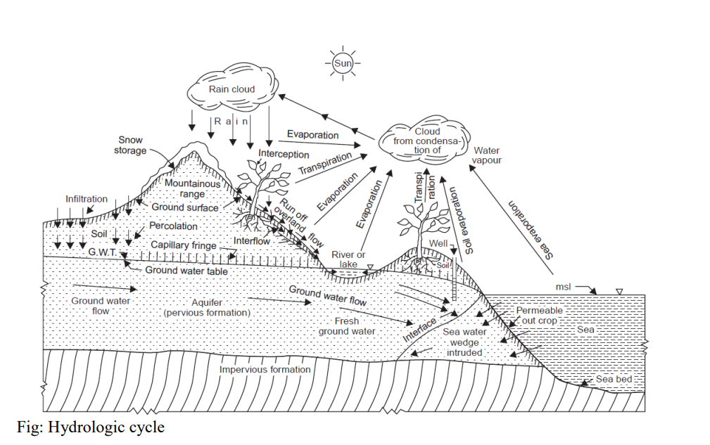
Hydrological cycle
Hydrologic cycle is the water transfer cycle, which occurs continuously in nature. Groundwater is part of the hydrologic cycle, originating when part of the precipitation that falls on the Earth’s surface sinks (infiltrates) through the soil and percolates (seeps) downward to become groundwater. Groundwater will eventually come back to the surface, discharging to streams, springs, lakes, or the oceans, to complete the hydrologic cycle. The three important phases of the hydrologic cycle are: (a) Evaporation and evapotranspiration (b) precipitation and (c) runoff. The globe has one-third land and Two thirds Ocean. Heat energy provided by solar radiation causes evaporation from the surfaces of ponds, lakes, reservoirs, ocean surfaces, etc. and transpiration from surface vegetation i.e., from plant leaves of cropped land and forests, etc. take place. These vapours rise to the sky and are condensed at higher altitudes by condensation nuclei and form clouds, resulting in droplet growth. The clouds melt and sometimes burst resulting in precipitation of different forms like rain, snow, hail, sleet, mist, dew and frost. A part of this precipitation flows over the land called runoff and part in filters into the soil which builds up the ground water table. The surface runoff joins the streams and the water is stored in reservoirs. A portion of surface runoff and ground water flows back to ocean. Again evaporation starts from the surfaces of lakes, reservoirs and ocean, and the cycle repeats.
Groundwater origin
Almost all groundwater can be considered as a part of the water cycle. Relatively small amount of groundwater may enter the water cycle from other origins, which is often called generic types of groundwater namely magmatic water, juvenile water and connate water.
1. Meteoric water Meteoric water is derived from the atmosphere, precipitating as rain or snow, and participating in the hydrological cycle. Although most of the rain water or melt water from snow and ice reaches the sea through surface flow or runoff a considerable part of precipitation infiltrates into the ground and percolates downward to meet saturation zone and become ground water.
2. Magmatic water or Juvenile water The water originated from magma is called magmatic water. It is water found in the cracks or pores of rock when condensation of steam from hot molten magma existing below the surface of earth. The magmatic water available at relatively shallow depths (probably 3 to 5 km) is known as volcanic water and when it is available at deeper depths (>3 or 5 km), it is called plutonic water.
3. Connate water Connate water is the water entrapped in the interstices of sedimentary rocks at the time of deposition and has been out of contact with the atmosphere for considerable time of a geologic period. This water might have been derived from oceanic or freshwater sources and is highly mineralized.
Groundwater movement and its occurrences
Groundwater originates from rain and from melting snow and ice and is the source of water for aquifers, springs, and wells. Groundwater is stored in and moves slowly through the layers of soil, sand and rocks called aquifers. The rate of groundwater flow depends on the permeability (the size of the spaces in the soil or rocks and how well the spaces are connected) and the hydraulic head (water pressure). Most groundwater originates as meteoric water from precipitation in the form of rain or snow. If it is not lost by evaporation, transpiration or to stream runoff, water from these sources may infiltrate into the ground. Initial amounts of water from precipitation onto dry soil are held very tightly as a film on the surfaces and in the micro pores of soil particles in a belt of soil mixture. At intermediate levels, films of water cover the solid particles, but air is still present in the voids of the soil. At lower depths and in presence of adequate amounts of water, all voids are filled to produce a zone of saturation, the upper level of which is the water table. Water present in a zone of saturation is called groundwater.
Occurrence
The water that goes below the surface of the earth may be found to exist in two main zones classified as vadose Zone and Saturated Zone.
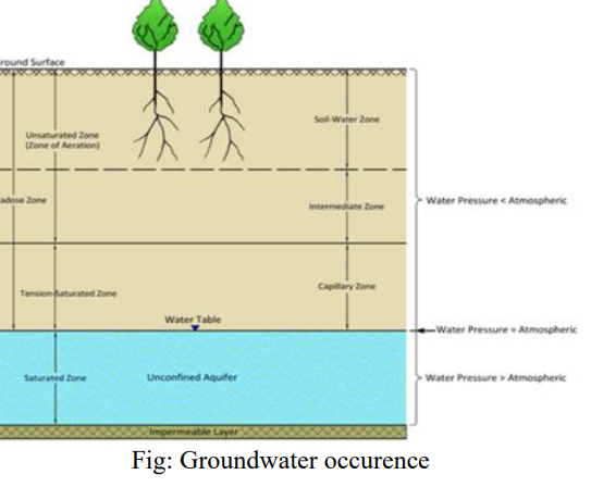
1. Vadose zone
The vadose zone, also termed the unsaturated/partially saturated zone, extends from the top of the ground surface to water table. The water pressure in the Vadose zone is less than the atmospheric pressure.
- Zone of Aeration The portion of the subsurface water in which the pore spaces in rock, soil material, are partially or temporarily filled with air is zone of aeration.
· Soil water zoneThis lies close to the ground surface in the major root band of the vegetation from which the water is lost to the atmosphere by evapotranspiration. This zone responds to local moisture conditions and precipitation.
· Intermediate zone This lies between the soil water zone and the capillary fringe. It lies below the zone of soil moisture and is usually dry. The water percolates through the intermediate zone to the water table.
- Capillary Zone Thread-like extensions of water which migrate upward by capillary action. It is subsurface zone in which groundwater extends a short distance above the water table to the limit of capillary rise.
2. Saturated Zone This zone, also known as groundwater zone, is the zone in which all the pores of the soil or fractures in are completely saturated with water. The water table forms its upper limit and marks a free surface i.e. a surface having atmospheric pressure.
Factors Controlling occurrence and movement of ground water
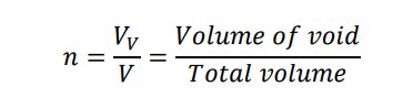
I. Porosity
Porosity is the percentage of rock or soil that is void of material. The larger the pore space or the greater their numbers, the higher is the porosity and larger is the water holding capacity. Porosity simply is the measure of water bearing capacity of geologic formations.
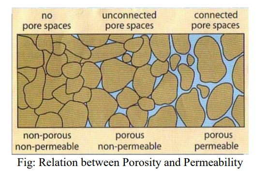
There are two types of porosity i.e. Primary porosity and Secondary porosity. Primary porosity is developed during deposition of sediments whereas the secondary porosity is developed after formation of rocks such as joints, cracks etc. Primary porosity mostly occurs in sediments whereas secondary porosity is related with igneous or metamorphic rock. Sorting and grain shape are the major factors affecting porosity. Well sorted sediments have greater porosity than poorly sorted sediments. Angular grained sediments tends to have low porosity as most of the voids between are filled with fine sediments than a rounded.
II. Permeability and Hydraulic conductivity
Permeability is property of soil which permits flow of water through it. Hydraulic conductivity is measure of a rocks capability to transmit fluid through its pore spaces. Permeability is a function of the size of pore openings and degree to which they are interconnected. If sediments are well sorted, pore spaces are uniformly sized, thereby allowing for groundwater to flow readily between individual sediment particles. If sediments are poorly sorted, pore spaces are filled with smaller sediments, hereby reducing the movement of water through the deposits. Permeability and Hydraulic conductivity is nearly similar. The difference is permeability is phenomenon whereas hydraulic conductivity is measuring parameter of that phenomenon. Fig: Relation between Porosity and Permeability.
III. Hydraulic head and Hydraulic gradient
In fluid mechanics head is a concept that relates energy in an incompressible fluid to height of equivalent static column of that fluid. It is defined as the energy possessed by a unit weight of the fluid.
Velocity head
The velocity head is elevation required to reach velocity (v) during flow of water through the soil.
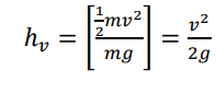
Where v is the flow velocity and g is the acceleration of gravity.
Elevation Head
It is elevation of any point that represents potential energy above reference level.
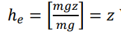
Where z is height of considered point above datum.
Pressure head
It is the height of a liquid column that corresponds to a particular pressure exerted by the liquid column on the base of its container.
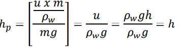
Where,
𝑢 = 𝑝𝑜𝑟𝑒 𝑝𝑟𝑒𝑠𝑠𝑢𝑟𝑒 𝑒𝑥𝑒𝑟𝑡𝑒𝑑 𝑏𝑦 𝑤𝑎𝑡𝑒𝑟 𝑖𝑛 𝑡ℎ𝑒 𝑝𝑜𝑟𝑒 𝑠𝑝𝑎𝑐𝑒
ℎ = ℎ𝑒𝑖𝑔ℎ𝑡 𝑡𝑜 𝑤ℎ𝑖𝑐ℎ 𝑤𝑎𝑡𝑒𝑟 𝑟𝑖𝑠𝑒𝑠 𝑖𝑛 𝑡ℎ𝑒 𝑝𝑖𝑒𝑧𝑜𝑚𝑒𝑡𝑒𝑟
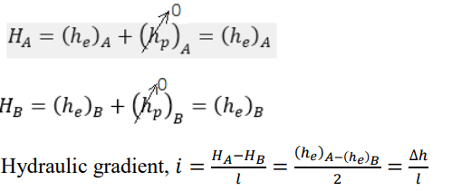
The hydraulic head, or total head, is a measure of the potential of fluid at the measurement point. The cumulative sum of all the heads with respect to a single datum in a fluid column is called as Hydraulic Head. But since groundwater velocity is very low velocity head is not considered in analysis. Thus in ground water flow Hydraulic head (H) = he + hp. Groundwater always flows from high hydraulic head to low hydraulic head.
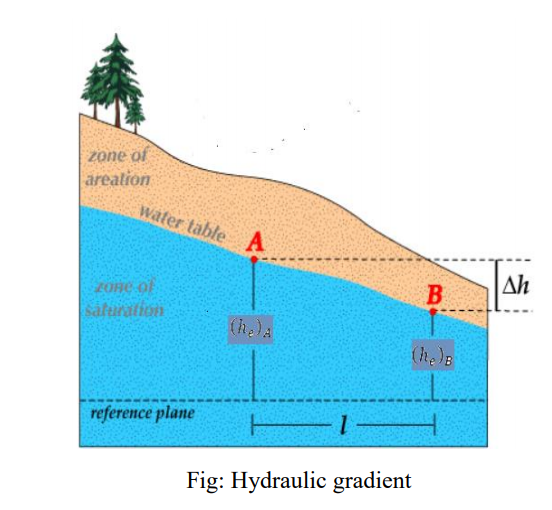
The loss or dissipation of hydraulic head per unit distance of the flow through the soil is called hydraulic gradient. The hydraulic gradient between any two points is the slope of the hydraulic head between those points. Ground water will flow down along the hydraulic gradient from higher hydraulic head to lower hydraulic head.
IV. Darcy’s law
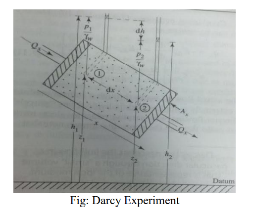
The law of flow of water through the soil was first studied by Henry Darcy in 1856 by studying the flow of water through sand filters.
Assumptions:
- The soil should be saturated and porous,
- Laminar flow across the soil is considered
- The steady and continuous flow is taken .
- The entire region of soil’s cross-sectional area is taken into account.
Darcy law states that the rate of flow per unit time (q) through the sand column is directly proportional to the head loss over the column length (dh) and cross-sectional area (A), and is indirectly proportional to the column length (dx).
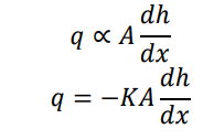
The constant of proportionality (K) is known as hydraulic conductivity of the porous medium. Negative sign indicates flow occurs in direction of decreasing head. The term 𝑑ℎ 𝑑𝑥 is head loss per unit length of flow and is called hydraulic gradient (i). Equation can be written as,
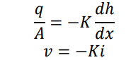
Where, 𝑣 is called Darcy velocity. Darcy’s law allows us to estimate groundwater flow rate if we know (or can estimate) the hydraulic gradient and the hydraulic conductivity.
Geologic formations
Aquifer
An aquifer is an underground geological formation which contains water and sufficient amount of water can be extracted economically using water wells. Aquifers comprise generally layers of sand and gravel and fracture bedrock.
Aquiclude
A geologic formation, which can absorb water but cannot transmit significant amounts is called an ‘aquiclude’. Examples are clays, shales, etc.
Aquifuse
A geologic formation with no interconnected pores and hence can neither absorb nor transmit water is called an ‘aquifuge’. Examples are basalts, granites, etc.
Aquitard
An aquitard is an underground geological formation which contains water but significant amount of water cannot be extracted using water wells. Ex clay lenses interbedded with sand.
Types of Aquifer
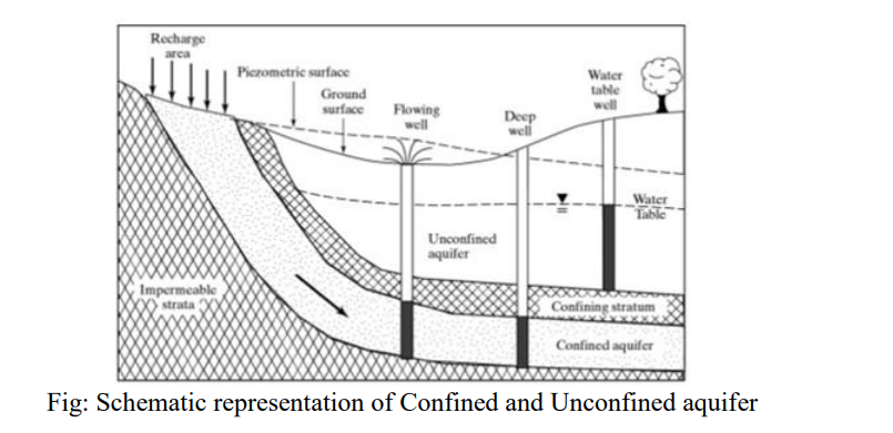
1. Unconfined aquifer
Aquifers which are bounded by a free surface (known as ‘water table’) at the upper boundary and a confining layer at the lower boundary are called unconfined aquifers. At the water table, water is at the atmospheric pressure, and hence unconfined aquifers are also called ‘water-table aquifers’ or ‘phreatic aquifers’. Unconfined aquifers receive recharge directly from the overlying surface through rainfall infiltration or percolation from surface water bodies. They usually exhibit a shallow water level. A typical indicator of an unconfined aquifer is that the water level in a well tapping this aquifer is equal to the water table position at that location of the aquifer.
2. Confined aquifer
Aquifers which are bounded both above and below by impervious or semi-pervious layers are called confined aquifers and the water present in these aquifers are under pressure greater than atmospheric pressure. Confined aquifers are sometimes also called ‘pressure aquifers’ or ‘artesian aquifers’. If a well is drilled into an artesian aquifer, the water level rises in the well to its initial level at the recharge source called the piezometric surface. Piezometric surface is imaginary surface that defines the level to which water in a confined aquifer would rise were it completely pierced with well. If the piezometric surface is above the ground level at the location of the well, the well is called ‘flowing artesian well’ since the water flows out of the well like a spring, and if the piezometric surface is below the ground level at the well location, the well is called a non-flowing artesian well. Unlike unconfined aquifers, confined aquifers don’t receive significant amounts of recharge from the overlying surface and is recharged by a natural source (by rain water when the formation outcrops at the ground surface, or outcrops imto a river-bed or bank) at higher elevations.
3. Perched Aquifer
Sometimes a small band of impervious strata lying above the main ground water table (GWT) holds part of the water percolating from above. Such small water bodies of local nature can be exhausted quickly and are deceptive. Such aquifer is called perched aquifer and the water level in them is called ‘perched water table’.
Well
A well is a hole usually vertically excavated in the earth for bringing ground water to the surface. It is of two types dug well and drilled well. Dug well is traditional types and generally excavated in uconfined aquifer i.e. shallow. Drilled well may be shallow or deep and depends on the depth of the well. Well upto 50 m is known as shallow well and greater than 50 m is known as deep well.
Springs
A spring is the result of an aquifer being filled to the point that the water overflows onto the land surface. A natural flow of groundwater from underground through pores, cracks, joints, or faults where water table intersects ground surface.
Types of Springs
1. Gravity Springs
The water gets pulled down through the ground until it reaches a layer it can’t penetrate. Because it has nowhere else to go, it starts flowing horizontally until it reaches an opening and water comes out as a spring. These are usually found along hillsides and cliffs.
- Depression Spring
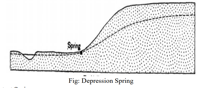
Depression springs are formed when the land surface dips (forms a depression) and makes contact with the water table in permeable material. Water yield will be good if the water table is high, but the amount of available water may fluctuate seasonally. A gravity depression spring may not be suitable for a drinking water source since it may dry up.
- Contact Spring
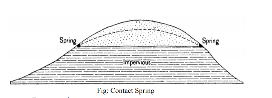
Contact springs are formed when downward movement of underground water is restricted by an impervious underground layer and the water is pushed to the surface. This type of spring usually has a very good flow throughout the year and is a good water source.
- Fracture spring
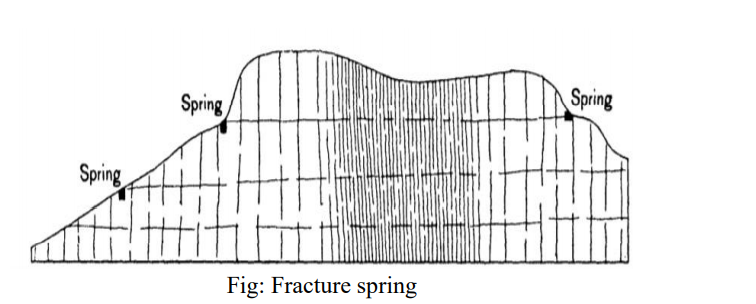
Due to fractures consisting of joints, bedding planes, columnar joints, openings due to cleavage, schistosity, cross-bedding planes, and faults in impervious sedimentary, igneous, and metamorphic rocks, water emerges out from fractures or joints in such rock as a spring called fracture spring. water movement through the rock in essentially the same fashion as in porous rocks but the essential difference is that in a porous rock water moves slowly through minute openings, whereas in fractured impervious rocks it moves more rapidly as sheets, threads, or films of water.
- Tubular Spring
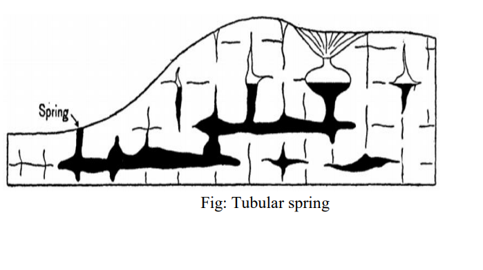
Tubular springs are those springs in which water flows from caverns. More or less rounded channels are formed in impervious rocks like limestones, calcareous sandstones, gypsum, etc due to solution of the rock by circulating ground water. Solution commonly begins along joints or other previously existing openings, and the channels may be enlarged to a very great size. In these tubes the water then flows freely and with relative rapidity.
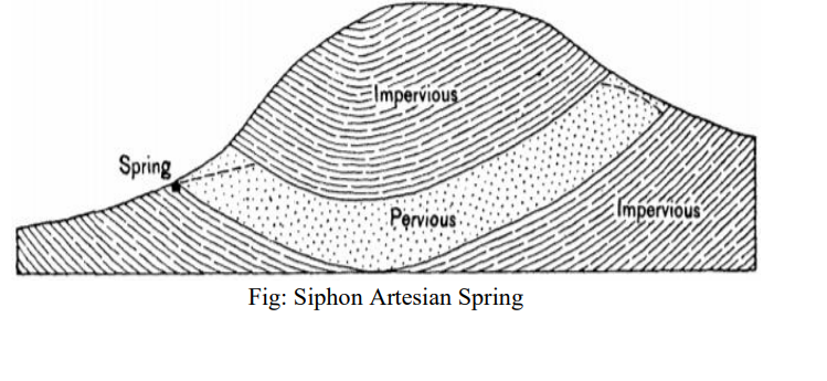
2. Artesian Springs
Artesian Springs occur when water trapped in pore spaces of a pervious bed between impervious layers is released under pressure.
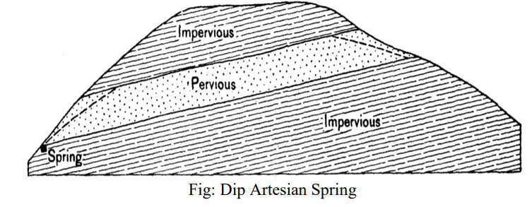
Dip Artesian Spring occurs in more or less regularly bedded rocks that have been tilted and eroded in such a manner that the porous bed receives water from the rain or streams in its upper end (porous bed outcrop) and that the lower end is exposed at the surface.
In a series of beds that has been folded, if the proper conditions of inflow and outflow exist, a porous stratum constitutes an inverted siphon for the conveyance of water. Springs due to the outflow from the low side of such a basin may be called siphon artesian springs.
SUBSURFACE WATER
Subsurface water also called groundwater is water that exists in the pore spaces and fractures in rock and sediment beneath the Earth’s surface. Groundwater is part of the hydrologic cycle, originating when part of the precipitation that falls on the Earth’s surface sinks (infiltrates) through the soil and percolates (seeps) downward to become groundwater. Groundwater will eventually come back to the surface, discharging to streams, springs, lakes, or the oceans, to complete the hydrologic cycle.
MOVEMENT OF GROUND WATER
Subsurface flow, in hydrology, is the flow of water beneath the earth’s surface as part of the water cycle. The flow of subsurface water serves to recharge the aquifers located at various depths and is very much important ecologically as it serves to complete the hydrologic cycle.
Controlling parameters
- Direction of flow
Groundwater is in constant motion, although the rate at which it moves is generally slower than it would move in a stream because it must pass through the intricate passageways between pore spaces in the rock. The direction of groundwater movement is dependent on the energy it possesses. Ground water moves from level of higher energy to levels of lower energy, its energy being essentially the result of elevation head and pressure head, the velocity heads being neglected since the flow is essentially laminar.
- Flow rate
The rate at which groundwater moves through the saturated zone depends on the permeability of the rock and the hydraulic head. Velocity of ground water flow which is entirely laminar is given by Darcy’s law which states that velocity of flow in porous medium is proportional to the hydraulic gradient. Groundwater movement in gravels and sands is relatively rapid, whereas it is exceedingly slow in clay or in tiny rock fractures. The amount of groundwater flow is greater with higher hydraulic conductivity, even if the hydraulic gradient is the same.
Significance of Groundwater movement
- Groundwater Recharge
Rainfall and snowmelt can runoff into streams or soak into the ground. The process of water soaking into the ground to become groundwater is known as groundwater recharge. Ground water recharge includes recharge as a natural part of the hydrologic cycle and human induced recharge, either directly through spreading basins or injection wells, or as a consequence of human activities such as irrigation and waste disposal. Typically, most water from precipitation that infiltrates does not become recharge. Instead, it is stored in the soil zone and eventually returned to the atmosphere by evaporation and plant transpiration. The percentage of precipitation that becomes diffuse recharge is highly variable, being influenced by factors such as weather patterns, properties of surface soils, vegetation, local topography, depth to the water table.
When discharge of groundwater exceeds recharge of the system, several adverse effects can occur. Most common is lowering of the water table, resulting in springs drying up and wells having to be dug to deeper levels. If water is pumped out of an aquifer, pore pressure can be reduced in the aquifer that could result in compaction of the now dry aquifer and result in land subsidence. In some cases withdrawal of groundwater exceeds recharge by natural processes, and thus groundwater should be considered a non-renewable natural resource.
- Ground water and watersheds
Groundwater in a water table aquifer usually moves in the same direction as water flowing over the land surface. Therefore, it stays in the same watershed where the rain or snow originally fell. A watershed is the area drained by a single river system Confined aquifers, which are much deeper than unconfined aquifers, sometimes are part of a regional groundwater flow system that does not match the surface drainage pattern. This allows groundwater to move from one watershed to another.
- Geologic Activity
Groundwater is an active weathering agent and can leach ions from rock, and, in the case of carbonate rocks like limestone, can completely dissolve the rock. The continued dissolution of rocks during groundwater flow can result in formation of following landform features:
- Caves and caverns
Large areas of limestone underground are dissolved by the action of groundwater forming cavities which eventually could expand to become caves or caverns (caves with many interconnected chambers). Once a cave forms, it is open to the atmosphere and water percolating in can precipitate new material such as the common cave decorations like stalactites (hang from the ceiling), stalagmites (grow from the floor upward).
- Sinkholes or Dolines
Sinkholes are circular or oval shaped depression formed either by erosion caused on the surface, by solvent action of water trying to enter into the ground or due to collapse of surface rocks forming roof of cave below. The former type of sinkhole where dissolution takes place on the surface is called solution sink and latter type where dissolution takes place below the surface of earth is called Collapse sink.
- Blind valley
A Blind valley is deep narrow valley with abrupt ending where stream flowing through it in upper reaches suddenly disappears in lower reaches by getting diverted into underground network of caves.
- Karst Topography
In an area where the main type of weathering is dissolution (like in limestone terrains), the formation of underground drainage system with blind valley, caves and sinkholes, and their collapse and coalescence may result in a highly irregular topography called Karst Topography.
ENGINEERING SIGNIFICANCE OF SUBSURFACE WATER
Subsurface water is often a critical factor in various engineering works. It may pose problems not only during the construction stage but it has a potential to affect the safe functioning of an engineering project. Almost every engineering project like, buildings, highway pavements, airport runways, dams, underground structures, structures on rock and soil slopes may be affected in one way or other by the subsurface water, which may lead to failure of such projects, thus causing loss of life and property. Therefore it is an important aspect of any engineering geological investigation to assess the possible adverse effects of the subsurface water on the proposed engineering projects.
Subsurface water affects site selection, cost, durability and even the safety of the structures. Subsurface water plays a prominent part in slope movement, volume changes by shrinkage and swelling and collapse of loose soils. It may also erode the foundation of the structures, Rocks and soil properties, which forms the foundation of the structures, are often changed by groundwater. Subsurface water may influence excavation and construction methods by flowing into excavations, by producing seepage forces and uplift pressures and also by its corrosive action.
Protective measures to control adverse effects of subsurface conditions
As the subsurface water has a most crucial effect in reducing the stability condition of the slopes, therefore all care must be taken to control the adverse effects of the subsurface water. This may be done by following two approaches, one as a preventive measure in which, efforts are made to reduce the excess inflow of the water into the slope and the second approach is the curative measures.
Slope De-Pressurization
Water pressure decreases the stability of a slope, it follows that reduction of this water pressure will increase the stability of the slope. The following points are important for slope de-pressurization:
- Prevent surface water from entering the slope through open tension cracks and fissures.
- Reduce water pressure in the vicinity of the potential failure surface by selective surface and sub-surface drainage.
1. Surface drain
Surface drains are designed to collect run off before it reaches the area immediately behind the crest of the slope. These drains are important because they are constructed in the area where tension crack occurs. Therefore, these drains must be cleaned from silt or clay or any blockage material, so that there is no pondage of water, which may enter into the tension crack which ultimately recharge the subsurface water.
2. Grading upper
Slope Surface The upper slope surface, immediately behind the crest, is an area of considerable potential danger since water, which is allowed to pond in this area will certainly finds its way into the slope through open tension cracks and fissures. Grading of this surface and the removal of piles of waste rock or overburden which could cause damming will enhance run-off of any collected water. 3. Sealing Open Tension crack
Open tension cracks are very dangerous in areas liable to higher intensity rainfall since the water forces generated by a water filled tension crack can be very high and can induce very sudden slope failures. In addition to diverting surface water away from open tension cracks, it is advisable to prevent water from entering the cracks, by sealing them with a flexible impermeable material such as clay. When the crack is more than few inches wide it should be filled with gravel or waste rock before the flexible seal is placed.
4. Horizontal and collection drain
Horizontal drain holes drilled into the slope face can be very effective in reducing water pressure generated by the subsurface water near the base of the suspected tension crack or along a potential failure plane. Water which is drained out of the rock mass should be lead away in collection drains otherwise this water will simply find its way into the next bench and the problem will transfer form one level to the lower level.
5. Vertical drainage wells
Vertical drainage wells drilled from the slope surface and fitted with down hole pump can be effective in slope drainage and de-pressurization.
Reference 1: Text book of Engineering Geology , N Chenna Kesavulu