Various landform on the surface of the earth
- Mountain
- Plateaus
- Shield
Mountain
• Mountain may be defined as any raised or elevated portion of the
landmass that is higher than the surrounding area.
• A long and narrow part of mountain is called Ridge.
• Mountains have complex internal structure due to folding, faulting,
volcanic activity and igneous intrusion.
Mountain ranges
A number of parallel or sub-parallel ridges formed during the same
mountain building process is known as mountain Range.
Mountain system
A number of mountain ranges formed during the same geological age
are known as Mountain system.
Mountain chain
A number of mountain ranges formed during different geological
Period are known as Mountain chain.
2. Plateau
This is an elevated land with a flat top and
steep slope on at least one side. E.g. The
Deccan plateau, the plateau of Tibet (2 million
square km) etc., It is formed as a result of huge
quantities of sheets of lava piled above
another.
- Shield
A large region of exposed basement rocks
commonly with a very gentle convex surface,
surrounded by sediments is called shield. E.g.
Canadian Shield, Baltic Shield.
Classification of mountain
- Tectonic mountains
a. Volcanic mountain
• Mountain formed by accumulation of production
of volcanic eruption is Volcanic Mountain.
• Erupted lava get deposited and solidified to form
huge dome shaped heaps that becomes
mountains when level is high.
b. Fault Mountain or Block Mountain
• During vertical or oblique motions along the fault
planes, sometimes a central block may be thrown
up or subside down with respect to the side
blocks.
• When central block is thrown up the central
elevated portion becomes higher than the
adjoining portion and when the central block
subsides down the central portion becomes valley
and raised portion on sides of depression become
Mountain.
Fold Mountain
Fold Mountains are mountains that form mainly by the effects
of folding on layers within the upper part of the Earth’s crust.
The movement of the two plates forces sedimentary rocks upwards
into a series of folds. At these colliding, compressing boundaries, rocks
and debris are warped and folded into mountains.
- Residual Mountain
The mountains which are formed by prolonged action of differential
erosion (caused by various erosion agents) acting on the pre-existing
plateaus are called Residual Mountains.
Weathering
• Weathering is a processes involving the physical destruction and
chemical decomposition of rock at the site of their occurrence.
• caused by the variations in temperature, by the chemical action of
water, by gases, by the biochemical action of organisms in the course
of vital activities and by the products of their decomposition after
they have died off.
Types:
A. Physical Weathering
B. Chemical weathering
C. Biological weathering
A. Physical Weathering
• It is natural process of disintegration of rocks into smaller fragments and particles
without including any chemical change in the end product.
• Physical weathering is a process of fragmentation of rock due to some physical
forces associated with the factors like fluctuations in temperature, change in the
pressure, growth of crystals, freezing of water, frost action etc.
• The main agents involved are wind, running water and glacier.
• The products formed are mainly coarse soils like sands, gravels.
Factors contributing to Physical weathering
• periodic contraction and expansion of rock due to variation in temperature
• Alternation of light and dark minerals, variation in expansion leads to
development of cracks.
• Freezing and thawing
• Roots of plants
• Movement of capillary water
B. Chemical weathering
• It is the process of alteration of rocks of the earth’s crust due to
chemical decomposition of rocks by the effect of atmospheric factors:
carbonation, dissolution, hydrolysis, oxidation, and hydration.
• The end product invariably has a different chemical composition and
poorer physical constitution as compared to the parent rock.
• Water plays an important role in chemical weathering.
• The results of chemical weathering are generally fine soils with altered
mineral grains. Carbonation and Dissolution
• As rain goes through the air and into the ground, it grabs carbon
dioxide, creating carbonic acid.
• This weak acid reacts with the calcium carbonate in rocks and
dissolves it when it seeps into the cracks.
- CO2 + H2O = H2CO3
- CaCO3 + H2CO3 = 2HCO3 – + 2Ca2 +
Hydrolysis
• The term hydrolysis combines the prefix hydro, referring to water, with
lysis, which is derived from a Greek word meaning to loosen or
dissolve.
• Hydrolysis is a chemical reaction where water loosens the chemical
bonds within a mineral and produce new compounds which tend to be
softer and weaker than the original parent rock material.
• This might sound the same as dissolution but the difference is that
hydrolysis produces a different mineral in addition to ions.
• An example of hydrolysis is when water reacts with potassium feldspar
to produce clay minerals and ions.
2KAlSi3O8 + 3H2O = Al2 Si2O5 (OH)4 + 4Si02 + 2K+ + 2OH–
Oxidation
• Oxidation is another kind of chemical weathering that occurs when
oxygen combines with another substance and creates compounds
called oxides
• When rocks, particularly those with iron in them, are exposed to air
and water, the iron undergoes oxidation, which can weaken the rocks
and make them crumble.
• Addition of oxygen results in less stable crystal and thus subjected to
disintegration and decomposition.Hydration
• Hydration is a type of chemical weathering where water reacts chemically
with the rock, modifying its chemical structure.
• A consequence of hydration is that the resulting mineral has a greater
volume than the original mineral.
• The increase in volume creates stress thus applying force to an overlying
layer and breaking it into pieces.
Physical and chemical weathering gives two weathering products
• Mobile ones which are transported over varying distances under the
action of gravity, sheet flow, erosion by water
• Residual products that remain on the site of destruction of the parents
rocks.
C. Biological Weathering
It is the disintegration or decay of rocks and minerals caused by chemical
or physical agents of organisms. Examples: organic activity from lichen
and algae, rock disintegration by plant or root growth, burrowing and
tunnelling organisms, and acid secretion.
Organic soil is formed as a result of biological weathering which is highly
compressible and is unsuitable for foundation material.
Factors affecting Rate of Weathering
Surface Area
The more of a rock’s surface that is exposed to air and water, the faster
the rock will break down. A greater surface area allows chemical
weathering to affect more of a rock.
Nature of Rock:
• Rock vary in chemical composition and physical constitution.
• Igneous rock like granite, basalt are hard and break very slowly while
Sedimentary rocks are soft and breakdown easily.
• Also highly jointed or faulted rocks present many planes of weakness
along which weathering agents (e.g. water) can easily penetrate into
the rock mass and cause weathering.
Climate:
• Weathering is intimately related to the climatic conditions prevailing in
an area.
• Chemical weathering occurs faster in hot, wet regions than it does in
cold, dry regions.
• However, physical weathering caused by freezing and thawing occurs
more in cold regions than in hot regions.
Physical Environment:
• The topography of the region in which a rock is exposed also effects the
rate of weathering.
• Rock forming bare cliffs, mountain slopes devoid of vegetation are more
prone to weathering than same rocks exposed in level lands in similar
climates and/or under cover of thick vegetation.
Engineering importance of rock weathering
• An engineer is always directly or indirectly interested in rock weathering
specially, when he has to select a suitable quarry for the extraction of
stones for structural and decorative purpose
• Strictly speaking the results of rock weathering or its probabilities at a later
stage is one of the most important point to be considered before giving a
final decision regarding the selection of quarry for the extraction of
weathered products
• It is also an important factor during the selection of site for important
projects such as a dam or tunnel as the process of weathering always
causes a loss in the strength of rock or soil.
Erosion
• It is process of physical removal and transportation of weathered
products by natural agencies such as water, wind, ice and gravity all of
which are characterized by motion.
• By virtue of their velocity the erosive agent remove the disturbed
material to far distances ranging from a few to thousands of
kilometers.
• The most important factors influencing erosion includes hydrological,
topographical, geological, vegetation conditions.Subsidence
It is displacement of the ground surfaces vertically over a broad region or at localized area. It may
be either a gradual lowering or a collapse which effects costly.
Mechanism of subsidence
• The dissolving of lime stones, salt or other soluble materials creates underground openings
• Breakage of roof of lava tubes in an area underlain by volcanic rock
• Withdrawal of fluids from subsurface reservoirs can create human- induced subsidence. e.g
extracting oil, gas and GW, underground mining
Damage due to subsidence
• cracking , tilting and shearing structure
• completely collapse
Evaluation
• Carried by geophysical methods, drilling
Mitigation
• controlling land use to avoid large scale changes in the regional WT
• avoiding withdrawal reinjected
• providing mined areas by selective support
Expansive soils
Soils that exhibit changes in volume with changing moisture content are
called expansive soils.
The capacity of a soil to shrink and swell is related to the clay minerals present,
particularly montmorillonite which can swell up to fifteen times its dry volume.
Mitigation techniques
• Excavate and remove expansive soils: this option is possible only if the expansive
soil is limited to a small area of the site.
• Extend building foundations beneath the zone of water content fluctuation.
• Apply civil engineering techniques for providing structural solutions to expansive
clay in new construction include upgraded structural slabs (post-tension, waffle,
mat) or elevated slabs supported on deep foundations. Their need and the design
parameters used in the design are provided by the geotechnical study.
• Stabilization of the soil by using products like hydrated lime, Portland cement etc. Mass wasting
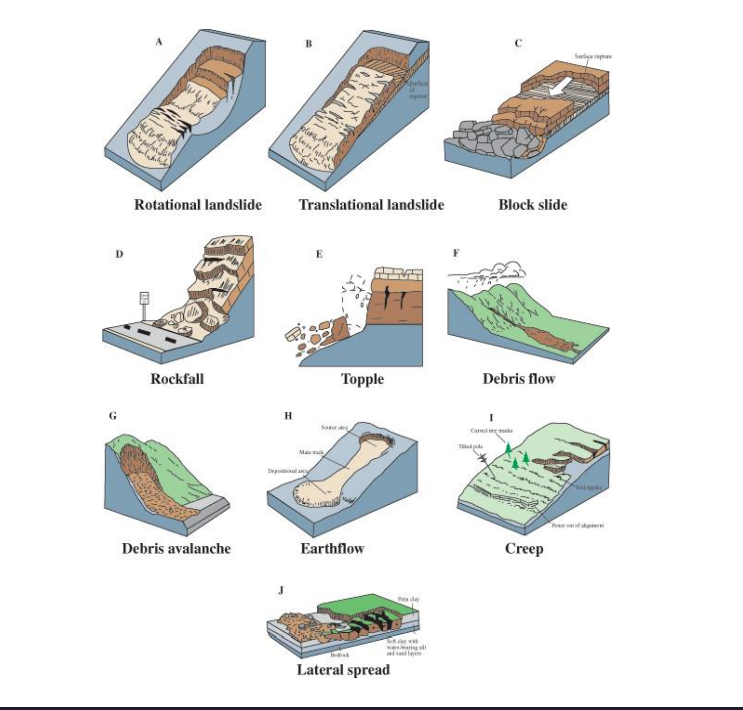
Large downslope movement of rock, soil and debris typically as a
continuous or discontinuous mass, due to the force of gravity and can
happen very slowly or very quickly.
Types of Landslide/mass movement according to Varnes
- Fall
- Topple
- Slides (Rotational and Translational)
- Lateral spread
- Flows (Creep, Debris flow, Debris avalanche, Earth flow, Mud flow
- Complex movements
- Fall
Falls are abrupt movements of the slope
material that becomes detached from
steep slopes or cliffs as separation occurs
along discontinuities such as fractures,
joints, bedding planes and movements
occurs by free-fall, bouncing and rolling.
2. Topple
Toppling failure are distinguished by the
forward rotation of a unit about some
pivotal point under the action of gravity
and forces exerted by adjacent unit or by
fluids in the crack that cause the unit to
separate from the main mass and fall to the
slope below.
3. Slides
Refer to mass movement where there is
distinct zone of weakness that separates the
slide material from more stable underlying
material.
Rotational Slide
This is a slide in which the surface of rupture
is curved concavely upward and the slide
movement is roughly rotational about an axis
parallel to ground surface.
Translational slide
In this type of slide, the landslide mass moves
along a roughly planar surface with little
rotation.
4. Lateral Spread
• usually occur on very gentle slopes or flat terrain.
• The dominant mode of movement is lateral
extension accompanied by shear or tensile
fractures.
• The failure is caused by liquefaction, the process
whereby saturated, loose, cohesion less sediments
are transformed from a solid into a liquefied state.
• Failure is usually triggered by rapid ground motion
such as that experienced during earthquake.
• When coherent material either bedrock or soil
rests on materials that liquefy the upper units may
undergo fracturing and extension and may then
subside, translate, rotate, integrate or liquefy and
flow.
5. Flows
a. Debris flow
- It is form of rapid mass movement in which combination of loose soil, rock, organic matter, air and water develop as a slurry that flows down slope.
- Flow include <50% fine particles
- Caused by intense surface water flow, heavy precipitation, heavy snow melt that erodes and mobilizes loose soil or rock on steep slope
- Debris flow source is often associated with steep gullies and debris flow deposits are usually indicated by the presence of debris fans at the mouth of gullies.
b. Debris avalanche
This is a variety of variety of very rapid to extremely rapid debris flow .
c. Earth flow
- During an earthflow a mass of weathered slope material that has been saturated with water flows downhill forming a bowl or depression at the head.
- Earth flows have characteristic hourglass shape.
- The downhill movement is slower and less fluidly than mudflow.
- It occurs in fine grained materials or clay bearing rocks on moderate slopes and under saturated conditions.
d. Mudflow
- A mudflow is the rapid movement of water that contains large amounts of suspended clay and silt.
- It contains at least 50 per cent sand, silt- and clay-sized particles and contains more water than earthflows.
e. Creep
- Creep is the imperceptibly slow, steady downward movement of slope-forming soil or rock.
- Creep is indicated by curved tree trunks, bent fences or retaining walls, tilted poles or fences, and small ripples.
- Complex movements
A complex movement is a combination of two or more types of
movements mentioned above. Generally huge-scale movements are
complex, such as rock fall, rock/debris avalanches.

Components of Landslide
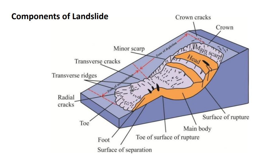
Crown
The practically un-displaced material still in place and
adjacent to the highest parts of the main scarp.
Main Scarp
A steep surface on the undisturbed ground at the
upper edge of the landslide, caused by movement of
the displaced material away from the undisturbed
ground. It is the visible part of the surface of rupture.
Head
The upper parts of the landslide along the contact
between the displaced material and the main scarp.
Minor Scarp
A steep surface on the displaced material of the
landslide produced by differential movements within
the displaced material. Surface of Rupture
The surface which forms (or which has formed) the lower
boundary of the displaced material below the original ground
surface.
Displaced Material
Material displaced from its original position on the slope by
movement in the landslide. It forms both the depleted mass
and the accumulation.
Toe of the Surface of Rupture
The intersection (usually buried) between the lower part of
the surface of rupture of a landslide and the original ground
surface.
Main Body
The part of the displaced material of the landslide that
overlies the surface of rupture between the main scarp and
the toe of the surface of rupture.
Foot
The portion of the landslide that has moved beyond the toe of
the surface of rupture and overlies the original ground
surface.
Surface of Separation
The part of the original ground surface overlain
by the foot of the landslide.
Toe
The lower, usually curved margin of the
displaced material of a landslide, it is the most
distant from the main scarp.
Zone of Depletion
The area of the landslide within which the
displaced material lies below the original
ground surface.
Zone of Accumulation
The area of the landslide within which the
displaced material lies above the original
ground surface.
Causes of Landslide
• Landslides can be triggered by both natural and man-made changes
in the environment conditions.
• The causes of landslide can be inherent, such as weaknesses in the
composition or structure of the rock or soil;
• Due to factors such as heavy rain, snowmelt, and changes in ground-water level as well as seismic or volcanic activities;
• Among these factors, rainfall, earthquake and human activities are
important trigger factors.
Geological cause
• Extensive
development of
weak rocks
• Weathering of rock
mass
• Sheared, Jointed or
fissured material
• Adversely oriented
discontinuity
(bedding, schistosity,
fault, etc.)
• Seismic activity
• Tectonic or volcanic
uplift
Morphological causes
• High relief
• undercutting of
banks by deeply
incised rivers and
streams
• subsidence
Physical causes
• Intense rainfall
• Rapid snow melt or
glacier lake outbrust
flood activation
• Freeze and thaw
weathering
• Shrink and swell
weathering
Anthropogenic causes
• Deforestation
• Improper land use
• Construction
activities
• Excavation of slope
or its toe
• Mining
• Water leakage from
utilities
• Loading of slope or
its crest
• Irrigation
• Road Construction
• Artificial Vibration
Control Measures
• Demarcating landslide prone areas and accordingly plan the future development activities.
• Enforcing proper land-use policies and regulations.
• Total avoidance of landslide hazard areas or by restricting, prohibiting, or imposing conditions on hazard-zone activity.
• Reduce the slope angle.
• Place additional supporting material at the foot of the slope.
• Reduce the load on the slope (rock, soil or artificial structures).
• Stabilize near-surface soil by preferably fast growing plants with sturdy root system
• Build thick retaining walls at the toe of the slope (high thin walls have been less successful)
• Decrease the water content or pore pressure of the rock or soil;
By covering the surface completely with an impermeable material and diverting the surface runoff above
the slope.
By providing surface drainage
By drilling boreholes (horizontal) to increase sub-surface drainage.
• Driving of vertical piles into the foot of a shallow slide to hold the sliding block (on thin slides and on low
angle slopes).
• Use of soil Nailing to to reinforce the soil
• Use of rock bolts to stabilize rocky slopes
Volcanism
• Volcanos are vent through which hot materials are discharged
continuously or immediately.
• The vents are naturally occurring and connect the surface of the earth
with molten material inside the earth.
• Volcanic activities occur frequently at the areas of plate boundaries.
• The magma inside the crust is under pressure and from fractures,
fissures, and other weaker planes in the Earth’s crust, the viscous hot
matter melts, and injects along these weak surfaces and when the cracks
extend up to the surface, the magmatic matter also starts erupting over
the ground, where it is called lava after its extrusion.
• This process of level intrusions (i.e., movement of magma within the
Earth’s crust) and eruptions is known as volcanism or volcanic activity.Materials of Volcanic Eruptions
Solid Products
• Solid rock fragments, called pyroclasts are thus ejected out along with molten
lava and may fall over the surrounding
• sometimes the liquid lava which is blown out into the air may get solidified and
fall back
Depending upon size solid pyroclasts are classified as:
a. Volcanic blocks
Angular solid fragments greater than 32 mm
b. Volcanic bombs
Lumps of lava solidified in air form a round body of size few cm to a metre.
c. Cinders or lapillis
The smaller size rock fragments varying in size from 5 mm to several centimetresd. Volcanic sand or Volcanic dust
The smaller sand size fractions of pyroclasts are called volcanic sands and still
finer fractions are successively called volcanic dust and volcanic ash.
e. Volcanic tuff and Breccia
The volcanic dust and ash, on consolidation along the volcano slopes, form a rock
called volcanic tuff while consolidation of a mixed mass of pyroclastic products
give rise to the rock type known as Volcanic Breccia.
Liquid Products
• Lava may be mafic (basic) or felsic (acidic) in composition.
• The mafic lava contain abundant Mg and Fe. They normally erupt at over 900
degrees Celsius and cool down to form basaltic rocks
• Felsic lava contain small amount of Mg and Fe but abundant Al, Na, and K. They
generally erupt at temperatures as low as 650 degree Celsius to 750 degree
Celsius which solidify to from acidic rocks
• The basic lavas are less viscous and more mobile compared to acidic lavas.3. Gaseous Products
• The main gaseous product of a volcanic activity is steam, which is let off
in enormously large quantities. The condensation of this steam towards
the end of eruption may result in heavy rains.
• Besides steam several other gases like nitrogen, hydrogen, carbon
dioxide, carbon monoxide, sulphur dioxide, hydrogen sulphide, fluorine
etc. may be evolved.
• These gases impart violent action to the volcanic outbursts in addition to
lowering the viscosity and melting point of the lava. They thus provide
mobility to the lava and also supply necessary pressure for its uplift in
the volcanic vents.
Classification of Volcano
- Continuity of eruption
• Active volcanoes
Active volcanoes are those, which are in action nowadays or have been
in active in the recent time
• Dormant or slumbering volcanoes
Dormant volcanoes are those which have not been in action in recent
times. But may have a chance to erupt again in future.
• Extinct
Extinct volcanoes are those which are geologically ancient and have
absolutely stopped their activities. - Nature of eruption
• Quite:
The lava erupts quietly without any explosion. The lava is of basaltic
composition, which is highly fluid and holds little gases.
• Intermediate:
The volcanoes erupt intermediate with explosion in the beginning and
gradually the explosion action dies down and lava is emitted quietly.
• Violent:
The volcano erupts explosively. The lava is acidic nature resulting high
degree of viscosity. Such volcano produce huge quantity of pyroclastic
materials. - Mode of eruption
central type:
• These are also referred as cone and crater type eruption. In such an
eruption the volcano consists of a central conduit joined by several
subsidiary channels through which magmatic eruption takes place.
• Fissure type:
These form another major group of eruption in which there is neither a
cone nor a crater. Lava flow out through the fissure and spread over
extensive areas. Such floods of lava continue for very long periods building
up new land forms from the lava flows.
Earthquake
An earthquake (also known as a quake, tremor) is the shaking of the surface of
the Earth resulting from a sudden release of energy in the Earth’s lithosphere
that creates seismic waves.
Terminology
• Seismology – The science dealing with the study of earthquake in all their
aspects is called seismology.
• Seismic – Used to qualify anything related to an earthquake. Eg seismic
waves, seismic intensity, seismic zoning, seismic region.
• Focus – The focus or hypocentre of an earthquake is a point at some depth
below the earth surface at which rocks in the earth’s crust start rupturing
and radiation of seismic waves starts. It may lie from a few hundred meters
to hundreds of Km below the earth surface.
• Epicentre – The point or place on the surface of the earth vertically above
the focus is called epicentre. It is place on the surface of the earth where
vibrations from a particular earthquake reaches first.
Elastic Rebound Theory
This theory explains how energy is stored in rocks. Rocks bend until
strength of the rock is exceeded. Rupture occurs and rocks quickly
rebound to an undeformed shape.
An earthquake occurs when energy stored inside the earth gets
released with great pressure.
When this happens earthquake waves transfer the released energy to
the surface of the earth.
The tremendous geological forces acting upon the rocks and adjoining
plates break the earth’s crust, thereby creating an earthquake with
sudden forceful impact.
Seismic waves – A seismic wave is an elastic wave generated by an
impulse such as an earthquake or an explosion that may travel either
along or near the earth’s surface (Rayleigh and Love waves) or through
the earth’s interior (P and S waves).
• The two main types of waves are body waves and surface waves.
• Body waves can travel through the earth’s inner layers, but surface
waves can only move along the surface of the planet like ripples on
water.
• Earthquakes radiate seismic energy as both body and surface waves.
Body waves:

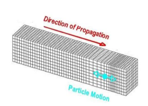
a. Primary waves
• compressional in nature
• travel like sound waves.
• The particles vibrate in longitudinal
direction i.e. in direction of propagation
of waves
• capable of passing through solids, liquids
and gases.
• The P waves are the fastest waves and so
the first wave to reach at the
seismograph station.

b. Secondary waves
• transverse in nature
• travel like light waves.
• The particles vibrate in transverse
direction i.e. in right angle direction of
propagation of waves
• capable of passing through only solids
• The S waves are the 2nd fastest waves
and so the second wave to reach at the
seismograph station.

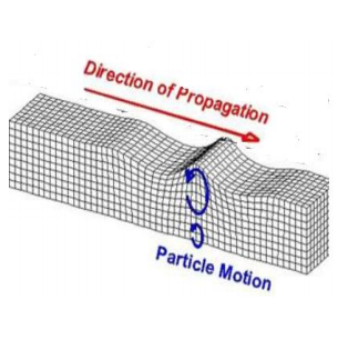
Surface waves
a. Love waves
• Fastest surface wave
• Moves ground side to side
• Confined to surface
produce entirely horizontal
motion

b. Rayleigh waves
• Rolls along the ground just like
a wave rolls across a lake or an
ocean
• Because it rolls, it moves the
ground up and down, and sideto-side in the same direction
that the wave is moving.
• It is the slowest seismic wave
and hence the last wave to
reach the seismograph
• Most of the shaking felt from
an earthquake is due to the
Rayleigh wave, which can be
much larger than the other
waves.
Epicentral distance
• The distance from a seismograph station to the place of origin of an
earthquake can be determined by the time interval between the
arrivals of the first P and S waves.
• The more distant the earthquake epicenter from the seismograph
station, the longer is the S.P. interval.

Magnitude and Intensity of Earthquake:
Magnitude
• Magnitude is the quantified value of seismic energy produced during
an earthquake.
• Magnitude is determined from measurements on seismographs.
• The Richter Magnitude Scale measures the amount of seismic energy
released by an earthquake.
• Magnitude of earthquakes is determined from logarithm of amplitude
of waves recorded by seismograph.
• An increase in magnitude by one implies 10 times higher waveform
amplitude and 31 times higher energy released.
Intensity
• Intensity is the qualitative measurement of the strength of shaking
produced by an earthquake.
• The intensity is a number (written as a Roman numeral) describing the
severity of an earthquake in terms of its effects on the earth’s surface
and on humans and their structures.
• While the magnitude of earthquake is determined using measurements
recorded on seismographs, the intensity is determined studying the
effects of earthquake on people, human structures, and the natural
environment and represented by certain scale.
• Several scales exist, but the ones most commonly used is the Modified
Mercalli scale.
Working of Seismometer (Seismograph)
• A seismometer is the internal part of the seismograph,
which may be a pendulum or a mass mounted on a
spring;
• Seismographs are instruments used to record the
motion of the ground during an earthquake and the
record of ground shaking generated by seismograph
(seismometer) on display or paper print is called
seismogram.
• A seismograph is securely mounted onto the surface of
the earth so that when the earth shakes, the entire unit
shakes with it EXCEPT for the mass on the spring, which
has inertia and remains in the same place.
• As the seismograph shakes under the mass, the
recording device on the mass records the relative
motion between itself and the rest of the instrument,
thus recording the ground motion.
• On a seismogram, the HORIZONTAL axis = time
(measured in seconds) and the VERTICAL axis= ground
displacement (usually measured in millimetres). • After measuring wave amplitude
from the seismogram, its
logarithm is taken and scaled
according to the distance of the
seismometer from the earthquake
focus, estimated by S-P time
interval.
• Then using nomogram the Richter
magnitude is obtained from the
value on the magnitude axis
intersected by the line joining
epicentral distance/ S-P interval
and Amplitude.
Classification of Earthquake
Earthquakes are usually classified on the following bases:
- Cause of Origin
Tectonic earthquake
Tectonic earthquake occurs when the plates move against one another
so that faulting or relative displacement of plates occur along rupture
surface.
Non tectonic earthquake
The Non tectonic earthquake occurs due to volcanic eruption,
landslide, atomic explosion, subsidence.2. Depth of focus
Shallow focus and deep focus earthquakes are both tectonic
earthquakes originating within the earth’s depths at various points.
seismic waves radiate outwards along the rupturing fault and all of rock
in the path of the wave is compressed and expanded alternately, as the
waves travel along the fault at great speeds.
• Shallow earthquake: foci less than 70 km depth
• Intermediate earthquake: foci is between 70-300 km depth
• Deep earthquake: foci is between 300-700 km depth
Shallow focus earthquake is more dangerous than deep focus
earthquake.3. Magnitude
Class Magnitude
A 7-8
B 7-7.7
C 6- 7.7
D 5.3- 6.0
E Less than 5.3
Stereographic Projection
Introduction
• In structural geology it is important to determine the orientations of
planes and lines and their intersections.
• The stereographic projection allows the three dimensional orientation data
to be represented and analysed in two dimensions.
• The idea is similar to representing the three-dimensional surface of the
Earth in two dimensions on a topographic map.
• The orientation of plane is representd by imagining the plane to pass
through centre of sphere.
• It is the methodology used in structural geology and engineering to analyse
the orientation of lines and planes with respect to each other by projection
of points from the surface of a sphere on to its equatorial plane.
Lower hemisphere Projection
• Used in structural Geology
• Projection Point above the centre of hemisphere
• Arc bows in direction of dipping plane
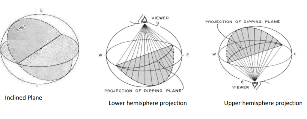
Upper hemisphere Projection
• Used in Mineral crystallography
• Projection point below the centre of the hemisphere
• Arc bows in opposite direction of dipping plane
Stereonet
A Stereonet is a lower hemisphere graph in which variety of geological
data is plotted
Two Types of Stereonet
• Equal Angle Stereonet (Wuff net)
Plotted angular relationships are preserved
Used in mineralogy
• Equal Area Stereonet (Schmidt net)
Used in Structural geology for orientation analysis when area is meant
to be preserved for statistical analysis
Construction of Equal Angle Stereonet
• Imagine a plane cutting through the centre of a lower hemisphere
• Looking from above, where the plane touches the edge of the lower hemisphere is an arc.
• Each point of this trace(arc) is to be connected with projection point in upper hemisphere.
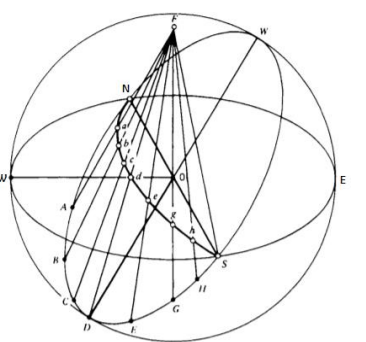
• While connecting each points of the arc with projection point it cuts the
horizontal plane (equatorial plane) and leave a trace on horizontal
plane.
• This will project the trace from hemisphere into equatorial plane as
great circle.
• If the plane is oppositely inclined then their traces in the hemisphere
will be projected on other side of equatorial plane.
• Accordingly different inclined planes traces can be projected on the
equatorial plane as different great circles.
• The planes that are coaxial to N-S axis resemble that of latitude and
project on the equatorial plane as small circle

.
• The trace on the hemisphere is projected on to the projecting plane tangent to the lower
hemisphere through Arc.
• The point A on the sphere is projected down to the plane by swinging this point in an arc
about the contact between the sphere and the plane, giving point B.
• The various points of the trace is transferred to the projecting plane to form great circle using
Arc
• Accordingly different inclined plane traces is projected into the projecting plane to form
various great circles.
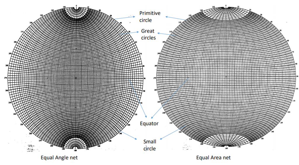
Elements of Stereonet
• The circumference of the equatorial plane which is outer perimeter of
the stereonet is termed the primitive circle.
• Circular Arcs that run from the north to south pole of the stereonet
are termed great circles and are analogous to lines of longitude on a
globe. (The larger the dip, the closer is the projection of the great
circle to the centre.)
• Circular arcs that run east-west are termed small circles.
• The stereonet grid is divided into two degree segments with a thicker
ten degree lines.
• Strikes and azimuths (bearings) are read around the primitive of the
stereonet.
• dips and plunges are read along the equator.
Setting up the stereonet
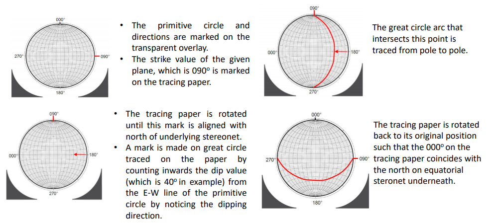
• Make a hole in the exact centre of the stereonet, by pushing the drawing pin through from the front of the stereonet. Then remove the drawing pin and push it through the hole from the back and tape it from back.
• Lay the tracing paper over the stereonet and push the drawing pin through it so that the paper freely rotates round the net
• Draw the outline of the stereonet on to the tracing paper and mark on north, south, east, west or 000o , 090o , 180° , 270°.Plotting of plane when attitude value is given as strike/dip dip direction e.g. 090o /40o S
Uses of Stereonet /Stereographic projection
• To restore the dip of the bed to pre-deformation attitude.
• To plot geometry of the fold
• To find intersection of planes
• To find displacement along faults
• To perform kinematic analysis
Kinematic Analysis
• Kinematics refers to the motion of bodies
• Method used to analyse the potential for the various
modes of rock slope failures (plane, wedge, toppling
failures), that occur due to the presence of
unfavourably oriented discontinuities.
•Uses stereographic projection
• Applied in rock stability Analysis
Plane failure
The failure surface in planar failures are resulted by structural discontinuities like bedding planes, faults or the interface between weathered rock and the underlying bedrock. This kind of failure leads to sliding action along the failure surface. Conditions:
• The joint plane and hill slope should dip in same direction
• The dipping of the joint should be less than dip of hill slope
• The dip of the joint should be more than friction angle
• The difference between dip direction of joint plane and hill slope should be between 20o .

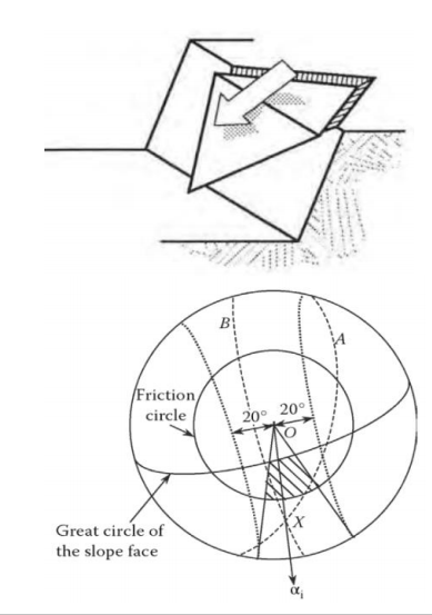
Wedge failure
Wedge failures involve a failure mass defined by two discontinuities with a line of intersection that is inclined out of the slope face. Conditions:
• The wedge and hill slope should dip in same direction
• The plunge of the line of intersection should be less than dip of hill slope
• The plunge of the line of intersection should be more than friction angle.
• The difference between trend of line of intersection and dip direction of hill slope should be between 20o .
Toppling failure
Toppling failure occurs due to steep discontinuities in the rock which eventually leads to slippage of the layers and the outward and downward movement of a column of rock. Here the column of rock rotates about a fixed point at the base of the slope. Conditions:
• The joint plane and hill slope should dip in opposite direction
• The dip of the joint plane should be more than friction angle.
• The difference between strike of joint plane and strike of hill slope should be between 20o .

Reference 1: Text book of Engineering Geology , N Chenna Kesavulu

