
1.1 Introduction
- Transportation engineering deals with planning, designing, implementing and maintaining the various modes of transportation system and infrastructure that required for transporting people and goods from one place to another.
- Transportation contributes to the economic, industrial, social and cultural development of any country. So, transportation plays vital role for economic development of any region.
- The main objective of good transportation system is to provide safe, economical, efficient transportation facility for the travel of passenger and transportation of goods.
1.2 Modes of transportation
A. Primary modes
1. Land transportation
a. Highways (Road ways)
Merit:
- Wide geographical coverage.
- Door to door service.
- High employment potential.
- Low initial investment.
- Economic for short distance.
Demerit:
- Environmental pollution.
- Low safety.
- High cost for long travel.
b. Railway
Merit:
- Economic for large distance.
- Fixed route.
- No traffic conjunction.
- Can transport large number of passenger and large quality of goods.
Demerit:
- Not economic for short distance.
- High initial investment.
- No different route.
- Material cost for construction is high.
2. Air transportation
Merit:
- Fastest mode of transportation.
- Large distance covered.
- Safe and comfortable.
- Connection to remote place is possible.
Demerit:
- High initial investment.
- Affected by weather condition.
3. Waterways
Merit:
- Economic for heavy load.
- Operating cost is low.
- Low environmental effect.
- Safest mode.
Demerit:
- Slow moving of transportation.
- Affected by weather condition.
- Chances of water pollution due to oil leakage.
4. Pipeline transportation
Merit:
- Can be laid over difficult terrain as well as under water.
- Operation and maintenance cost is low.
Demerit:
- Security of pipeline is difficult.
- Initial cost is high.
B. Secondary modes
1. Ropeways
- Economic.
- Used in steep slope.
- Environmental friendly.
2. Belt conveyors
- Provide steady movement of material.
- Used in industries for transport of goods.
3. Canal
- Used in transportation for irrigation system in rural areas.
1.3 Comparison between various modes of transportation
| Transport | Accessibility | Speed | Capacity | Initial Cost | Operating Cost | Efficiency |
| Roadways | High | Moderate | Moderate | Moderate | High | Moderate |
| Railways | Moderate | Moderate | High | High | Moderate | High |
| Airways | Low | High | Low | High | High | Low |
| Waterways | Low | Low | High | High | Low | High |
| Pipeline | Low | Low | High | Moderate | Low | High |
1.4 Historical development of roads
- First mode of transportation was by foot which led to development of footprint.
- Use of animal and development of trackways.
Historical classification of roads:
1. Roman road (7th Centuries)

- Built regardless of gradient.
- Used heavy foundation at bottom.
- Concrete was a major roman road making innovation.
- Roads were very costly.
2. Tresaguet road (1764 AD – 1775 AD)
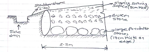
- Also known as French road.
- Side drainage was provided.
- Thickness of construction was only 30 cm.
- Pavement used 200 mm pieces of quarried stone.
3. Telford construction (1757 AD – 1834 AD)
- Also known as England road.
- Slopping surface on the top was provide by varying size of stones in foundation.
- Cross – drains at interval of 90 m was provided.
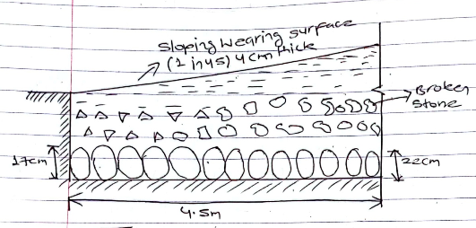
4. Macadam construction

- First scientific road construction method.
- Economical method.
- Instead of placing large foundation stone, small size broken stone are spread over the prepared subgrade and compacted.
- Proper drainage system was considered.
1.5 Road construction in Nepal
- Government of Nepal has been giving priority to development of roads since the beginning of planned development programmed established in 1956 AD.
- The first motorable road was constructed in the Kathmandu Valley.
- Nepal’s first paved road was built with aid from India in early 1950’s.
- Nepal’s first highway was Tribhuvan highway (25 Km) in 1956 AD.
- The government of China built Araniko highways (115 Km) in 1966 AD.
- Prithivi highway (200 Km) was built in 1974 AD.
- Roads construction in Nepal:
| Year (AD) | Road Length (Km) |
| 1950 | 376 |
| 1970 | 2564 |
| 1980 | 4904 |
| 1990 | 7007 |
| 2000 | 14000 |
| 2020 | 23000 |
| 2022 | 74756 |
- Agencies involved in road development of Nepal are:
- Ministry of Physical Planning and Works
- DOLIDAR
- Ministry of Finance
- National Planning Commission
- Nepal Army
- JICA
- Bilateral Agency (India, UK, Japan, China)
- Multilateral Agency (AOB, JMF, WB)
- Swiss Development Cooperation (SDC)
1.6. Transport planning including objective of road planning
- Transport planning is done to develop a reliable, cost effective, safe facility oriented and sustainable transport system that promotes and sustains the economic, social, cultural and tourism development of Nepal as a whole. (According to National Transport Policy 2058 BS)
Objective of transport planning:
- To determine existing road network.
- To collect the demand of road network.
- To mobilize the resource.
- To forecast future need of road in different part of country.
- To improve traffic capacity.
Different studies in project planning survey:
a. Economic Studies
- Population and its distribution pattern.
- Trend of population growth.
- Agricultural and industrial product of the area.
- Possibility of industrial and agricultural development.
- Existing facilities with regard to communication, education, health etc.
b. Financial Studies
- Source of income and estimated revenue.
- Living standard.
- Resources of local level, toll taxes, vehicle registration and fines.
- Future trends in financial aspects.
c. Traffic Studies
- Traffic volume, annual average daily traffic.
- Origin and destination studies.
- Traffic flow pattern.
- Accident, their cost analysis and causes.
- Future trend in traffic volume and pattern.
d. Engineering or Technical Studies
- Topographic survey.
- Soil survey.
- Location and classification of existing road.
- Estimation of possible development in all aspect.
- Road life studies.
- Traffic studies.
e. Long term planning
- Population model.
- Economic activity mode.
- Land use model.
- Traffic assignment model.
- Trip generation model.
- Trip distribution model.
- Model split model.
Types of road planning
a. National Road Network (NRN) planning
- Planning of main highway in Nepal connecting major parts of country, headquarter of regions and large industries and tourist centre including roads required for strategic movement for defense of country.
- Also includes feeder roads.
- East – West and North – South highways.
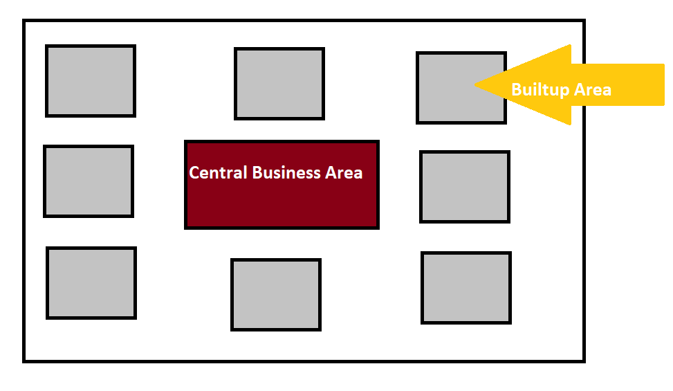
b. Urban Road Network (URN) planning
- The roads serving within the urban municipalities.
- Urban areas are communication centre for the exchange of goods, service and ideas.
1.7 Classification of roads
- According to Nepal Road Standard 2070 BS roads in Nepal are classified as follows:
A. Administrative classification
1. National highway
- Main roads connecting east to west and north to south.
- Provide consistently higher level of service in terms of travel speeds.
- Designated by letter ‘H’ followed by a two digit number.
- For example: HO1, HO2 etc.
HO1 – Mahendra Rajmarga
HO2 – Tribhuvan Rajmarga
- Total national highway = 21
2. Feeder roads
- Connect district, headquarters major economic centre, tourism centre to national highway or other feeder roads.
- Important roads or localized nature.
- Wide community interest.
- Designated by letter ‘F’ followed by three digits.
- For example: FOO1, FOO2 etc.
FOO1 – (Birtamod – Bhadrapur)
FOO2 – (Balkhu – Dakchhinkali)
- Total feeder roads = 209
3. District roads
- Important roads within a district.
- Serves production areas and market.
- Connecting with each other or with the main highways are district roads.
4. Urban roads
- Roads serving within the urban municipalities are urban roads.
Classification of urban roads:
a. Expressway:
- They are provided for speedy and heavy traffic.
- Pedestrian not allowed.
b. Arterial:
- They are provided for heavy and important traffic inside the city.
- Pedestrians are allowed to cross only at intersections.
c. Sub – arterial:
- They are provided for less traffic than arterial streets.
- Pedestrians are allowed to cross only at intersection.
d. Collector:
- They are provided for indirect and direct access for land users within specific area.
- Full access allowed from properties alongside.
e. Local streets:
- They are provided for direct property access.
- Does not carry large volume of traffic.
Notes:
a. Strategic Road Network (SRN):
- National highway and feeder roads.
- DOR governs strategic road network.
b. Local Road Network (LRN):
- District roads and urban roads.
- DOLIDAR and Local government governs local road network.
B. Technical functional classification
1. Class I (Expressway)
2. Class II (Arterial roads)
3. Class III (Collector roads)
4. Class IV (Local roads)
Notes:
Average daily traffic: ADT
Passenger car unit: PCU
| Class | ADT in 20 yrs perspective period | Design speed in plain terrain |
| I | 20,000 PCU or more | 120 Kmph |
| II | 5000 – 20,000 PCU | 100 Kmph |
| III | 2000 – 5000 PCU | 80 Kmph |
| IV | < 2000 PCU | 60 Kmph |
- Unit used for expressing highway capacity.
| Type of vehicle | Car | Motorcycle | Bus/ Truck |
| PCU | 1 | 0.5 | 3 or 4 |
Road patterns in urban roads:
1. Grid iron pattern:
a. Rectangular or block
b. Hexagonal

Advantage:
- Low cost.
- Simple to plan.
- Efficient in providing drainage and sewerage network.
Disadvantage:
- Offers limited urban design options.
- Can be confusing and frustrating.
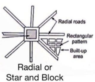
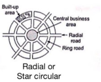
2. Radial pattern:
a. Star and block
b. Star and circular
c. Star and grid
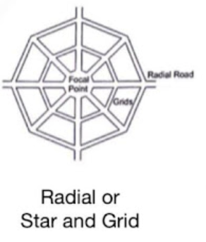
Advantage:
- Reduce traffic.
- Less risky as compared to block patterns.
- If one road is blocked another can be used as alternative.
Disadvantage:
- Lack of safety.
- High construction cost.
3. Ring roads:
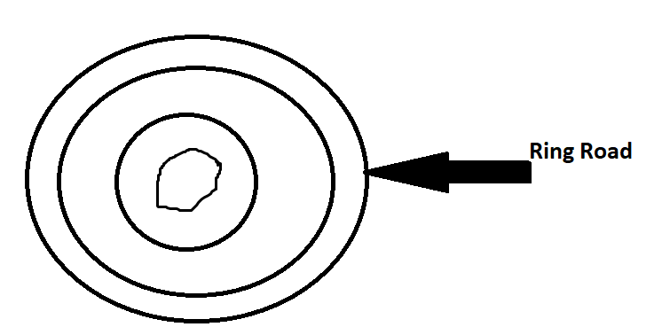
Advantage:
- Direct access to the town centre like business area, banks, shopping complexes, entertainment centre etc.
- Reduce traffic.
Disadvantage:
- High construction cost.
- Speed has to be limited approx. 100 Kph.
References:
- Sharma, S.K Principles Practice and Design of Highway Engineering. New Delhi: S. Chand and Co. Publisher Ltd.
- Relevant Publication by Department of roads and department of local infrastructure development and agricultural roads (DOLIDAR).